Before the BeltLine
A century ago, multiple railroad segments laid the groundwork for the BeltLine’s future loop
Sponsored by AT&T

Photo: Jenni Girtman.
On the hardwood floors of Angel Poventud’s house, construction documents for the BeltLine’s Westside Trail are arrayed from the kitchen to the living room like a thick, white snake. A large, framed map of Atlanta from 1969, which Poventud (in photo) found in an abandoned maintenance facility on the BeltLine, hangs in the living room. Crouching over the documents, pointing at the map, he expounds on the historical significance of the BeltLine corridor in a raspy voice with surfer-dude dialect, calling the circular patchwork of old railroads Atlanta’s original Interstate 285.
“The BeltLine was built to bypass the city,” says Poventud, a CSX freight train engineer who’s led BeltLine tours since 2009, catering to groups as disparate as Georgia Tech freshmen and Centers for Disease Control and Prevention employees. “But as a result of ‘If you build it, they will come,’ it brought a lot of energy to the city.”
The same can be said for the BeltLine of today. But there’s a key difference between what today’s BeltLine aims to be — a 22-mile emerald necklace around intown Atlanta, complete with light-rail transit — and yesterday’s railroad networks: contiguousness.
Contrary to what Atlantans might think, this oval of railroads was never a single rail line, never controlled by a single company. Rather, the story of the BeltLine involves four different sections that were built and abandoned (with one exception) at different times. Given this fragmented history, it makes sense that BeltLine construction continues in fits and bursts — and likely will until the loop finally comes together, this time moving people in the way it once transported coal, Sears & Roebuck Co. products and the raw materials that built Atlanta.
All four original BeltLine sections came after the Civil War, when booming cities like Atlanta relied on “belts” of railways to expand their industrial bases and bypass population centers. None of Atlanta’s belts were considered major lines, which means historical documentation of their construction, operation and freight isn’t exactly plentiful. But BeltLine diehards like Poventud have compiled enough data over the years to shed light on the project’s ancestors.
Poventud’s restored 1923 bungalow in Adair Park obliges historic color palettes for the area — auburn, jade and deep red — and backs up to the under-construction Westside Trail, which is the section, historically speaking, that experts know least about. “It’s hard to pin down a date about when it was even built,” says Ryan Gravel, the Atlanta architect whose 1999 master’s thesis provided the original vision for the BeltLine.
Standing in his backyard one April afternoon, beside a gully of churned dirt and construction fencing, Poventud explains that trains once traversed the neighborhood on two main-line tracks. Spurring relatively little industry (compared with sections on the east side of town, where Poventud says Sears was “the Amazon.com of its day”), the tracks left many old-growth trees in place.
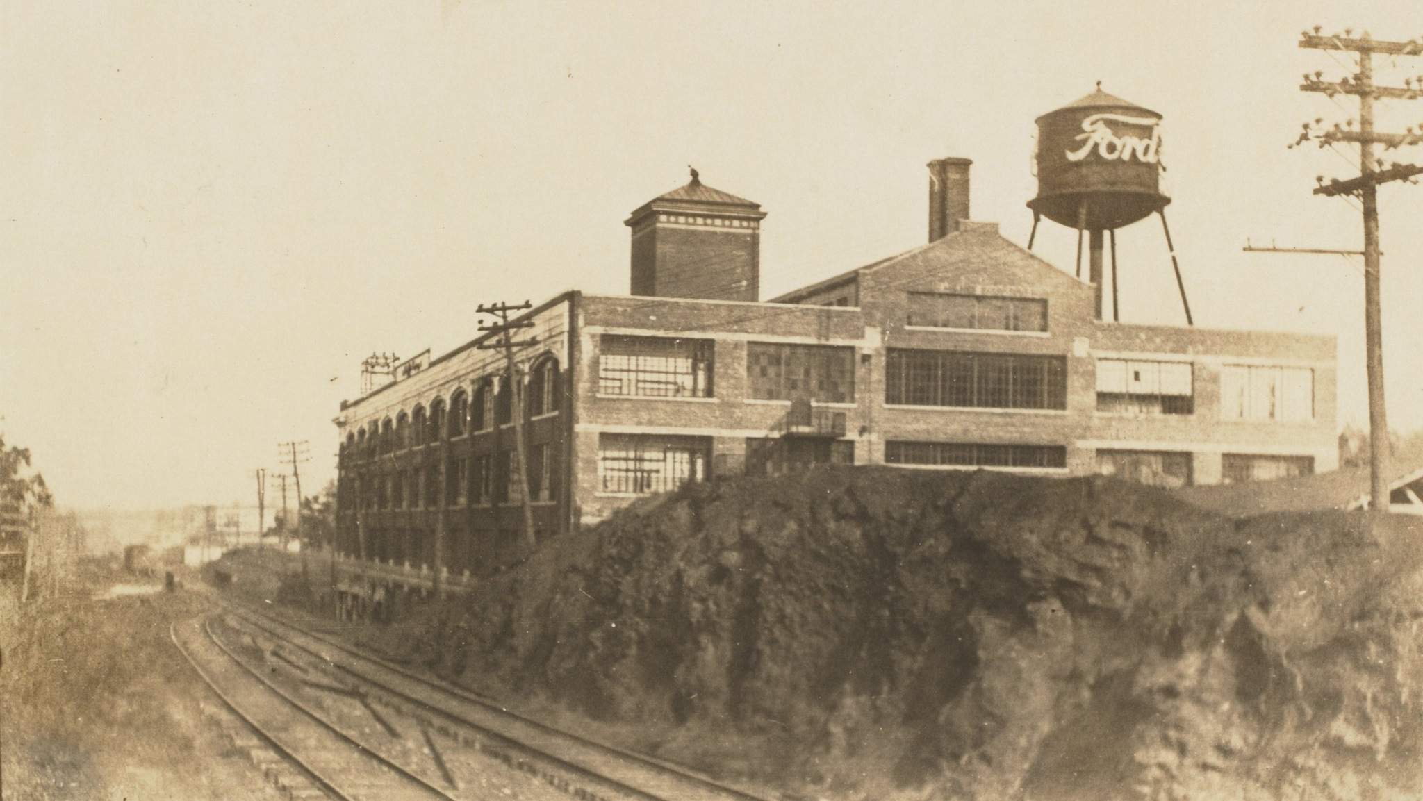
A view looking west with the old Ford Motor Plant on the right, which was on Ponce de Leon. This set of tracks is definitely used for the BeltLine today
Records indicate this railway on Atlanta’s southwestern flank, called the Louisville & Nashville Railroad Belt Line, was operational in 1902. Land near the northern end of the tracks — where neighborhoods such as Mozley Park, Ashview Heights and Hunter Hills are today — was originally zoned for industry that never came. The Georgia Department of Transportation bought the corridor to build a roadway for trucks, planning to connect industrial northwest Atlanta to Interstate 20, but that never materialized, either. Poventud’s research indicates this segment has been dormant for 40 years; Gravel says he has seen pictures that suggest it was “at least marginally operational” until the early 1980s. In any case, GDOT and BeltLine officials inked a purchase option and lease agreement in 2009.
Heading south from the Westside Trail, bending around Turner Field, reveals a 4.3-mile rail segment that will be called the Southeast (or South) Trail, stretching up to Grant Park. Historically, this corridor was known as the Atlanta & West Point Belt Line Railroad, built in 1899 because the owners weren’t able to run a line into downtown Atlanta, where competition from other railroads was fierce. After a series of mergers, the line eventually came under the control of CSX in 1980 and became colloquially known as “the sand train” for the material it delivered to eastside concrete facilities. Poventud says CSX, his employer, put the line out of service in May 2014, and no deal with the BeltLine has been reached for its use.
“[CSX] is just holding it right now,” he says.
Circling to the north, from the modern-day Eastside Trail to the unbuilt path in Buckhead, is the section where the Atlanta & Richmond Air Line Railway tracks were laid in the 1870s, decades before the city’s other belts. Commonly called the Southern Railway, this line “played the greatest role in the life of the city,” Gravel says, in that it once linked to downtown and hauled goods from the Sears distribution center and other key industries.
Norfolk Southern Railway used the line as recently as the 1990s to access industrial sites near today’s Historic Fourth Ward Park skatepark. Even younger Atlantans can sorely recall being delayed by these trains on Monroe Drive at Piedmont Park, Poventud says.
Looping around Buckhead, heading back toward the Westside Trail, leads to the lone section of BeltLine railway that’s still thriving — and that no one anticipates will go dormant. This 3.5-mile segment of the loop, the Seaboard Air Line Railroad, was completed in 1892, and Poventud says CSX still runs about 20 trains on it daily. This section is also unique in that the BeltLine’s multi-use trail and rail transit will likely be divorced from each other when fully built here.
“The idea there is the [BeltLine] transit would share the corridor as MARTA shares the corridor all over the region, and CSX shares their transit corridors with transit agencies all over the country,” Gravel says. “So it’s the logical thing to do.”
As with the southeast corridor, a BeltLine deal with CSX has yet to happen in the northwest section.
While poring over still more maps in his kitchen, Poventud says Atlantans are lucky, in a sense, that the inner city’s population decreased as railroad shipping was supplanted by trucking. Otherwise, the paths born by the belt lines of yesteryear might have already been developed — instead of being catalysts for development.
“The BeltLine is really the infrastructure to build the city for the next 100 years,” he says. “It’s going to redefine how the city operates.”
Insider tip
For a broader perspective on Georgia’s railroad history, visit railga.com, where even non-rail buffs can find interesting facts and rail-related photography.
Insider tip
For Atlantans geeky enough to enjoy aerial mosaic photos of the city that show early rail lines, the website for Georgia State University’s Digital Collections (search “Planning Atlanta”) provides hours of brain candy at digitalcollections.library.gsu.edu.
The SeaBoard rail line looking towards the old Sears building, which would become City Hall East and is now Ponce City Market.

BeltLine people: Angel Poventud
A freight train engineer by day, community activist Angel Poventud has been a champion of the BeltLine for more than a decade. Several times a year, he offers walking or biking tours of the BeltLine: Check “Beltline Walks ATL by Angel” on Facebook for updates. He lives in a renovated home that fronts on Adair Park and backs to the BeltLine’s Westside Trail.
What’s your favorite part of the BeltLine?
The Westside Trail has my favorite sections of trail. It was the last [of the rail] to be built and the first to be abandoned, so it has the least amount of industrial land. The neighborhoods and tree canopy push up against it, and the bridges along it have a little more character. I’ve walked it in all weather, including five inches of snow. It really is beautiful.
How did you first learn about the BeltLine?
The 2004 “Emerald Necklace” study [by Alex Garvin & Associates] and its global view of whole neighborhoods — that was my introduction to the BeltLine. Until then, I didn’t know what we were missing. The city got both bigger and more connected and smaller. I went from being a Midtown resident to a resident of the BeltLine.
As a train engineer, what’s your perspective on Atlanta from the rails?
My territory is Atlanta, Athens and Gainesville. It’s what we call “the brain train line” connecting Emory University to the University of Georgia. I can get a freight train from the Westside of Atlanta to Athens in two and a half hours, carrying 12,000 tons of corn or 10,000 tons of ethanol on trains a mile long. I started riding the rail in 2005, seeing how the Waterworks is connected to Piedmont Hospital is connected to Lindbergh — in real time. People say “We should connect things [in Atlanta],” but from my perspective, they’re seamlessly connected already.
— Curt Holman
